EGM96: The NASA GSFC and NIMA Joint Geopotential Model
EGM96
The NASA GSFC and NIMA Joint Geopotential Model
Table of Contents
General Description
Principal authors and collaborating institutions
Link to the EGM96 web page at NIMA
(now
NGA or National Geospatial-Intelligency Agency.
)
Availability of the Surface gravity Data
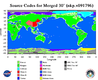
Map of source codes used in final surface gravity merged file
How to retrieve the spherical harmonic coefficients.
Satellite tracking Data in EGM96
EGM96: Design Considerations
EGM96: Method of Solution
Calibration of the Satellite Only Solution
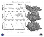
Example: Calibration factors for SPOT2 & STELLA
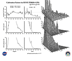
Example: Calibration factors for EUVE
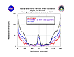
Plot: RMS Error Per Degree per Coefficient for EGM96S
Development of the Combination Model
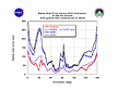
Plot: RMS Error per Degree per Coefficient for the combination model EGM96 (through deg. 70)
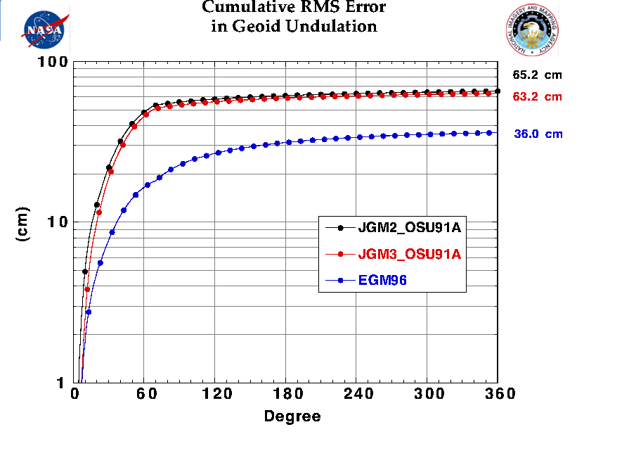
Cumulative RMS error in geoid undulation.
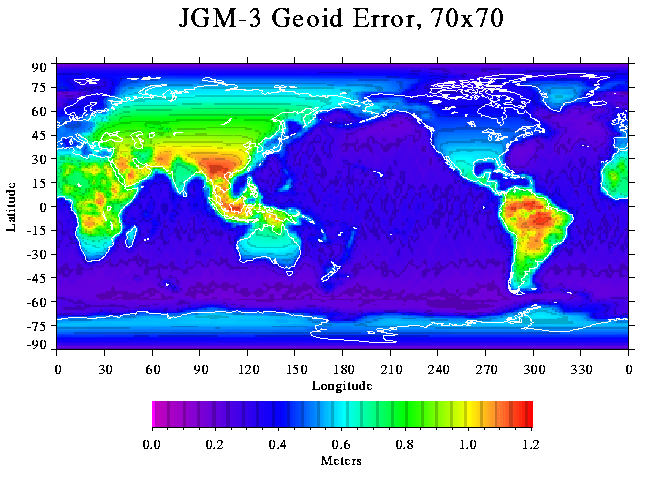
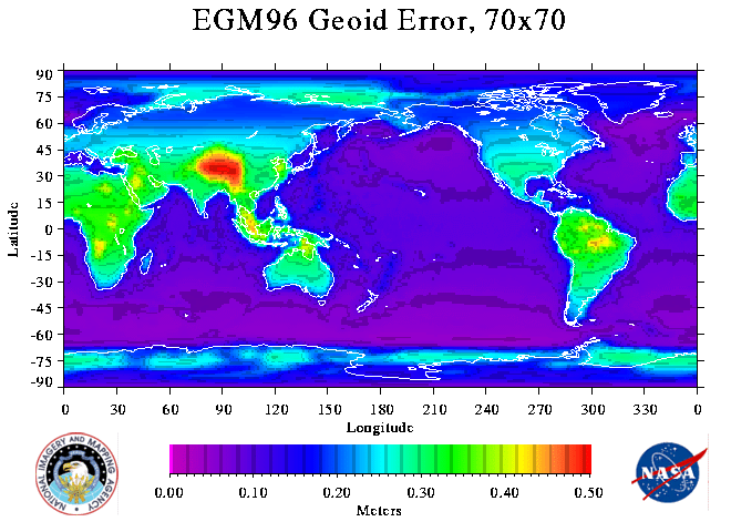
Calibrated Geoid Error From the JGM-3 and EGM96 Covariances
Geographical Breakdown of Calibrated Geoid Error
Radial orbit error projections vs inclination for JGM2, JGM3, and EGM96.
Satellite Orbit Error Predictions resulting from Gravity Model Error.
TOPEX/POSEIDON
,
SPOT-2
,
AJISAI
,
GEOSAT
,
LAGEOS-1
,
LAGEOS-2
,
STARLETTE
,
STELLA
,
GEOS-3
,
PEOLE
,
BE-C
,
D1C
,
D1D
,
ERBS
,
EP/EUVE
,
C-GRO
,
XTE
,
TRMM
,
GFZ-1
,
ERS-1
,
EOS
,
GLAS
:
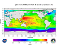
QSST derived from TOPEX and ERS-1 altimeter data with the EGM96 solution
Model validation using dynamic ocean topography comparisons
GPS/Leveling Comparisons (NGS dataset, USA)
GPS/Leveling Comparisons (British Columbia)
Global Doppler positioning/Leveling Comparisons
Acknowledgements
Bibliography
Links to other pages
back to top of table of contents
back to EGM96 home page

 back to EGM96 home page